


Tourism and leisure
The Old Warmian House is an excellent place for tourism and leisure, as much in summer as in the winter period. The house has an outdoor pool and a kayak dock by the Kiermaz river, ca 1.5 km to Lake Umląg (available electric motor boat and kayaks). Excellent sites for hiking, bicycle touring, horse riding, fishing and photo „safari” around the house. First-rate trails for winter cross-country skiing in the immediate vicinity of the house.
You can also use services of professional leisure centres. In the immediate vicinity, there are several stud farms offering horse riding rental and a kayaking tour operator (see the tour offer below).
I Kośna – Łyna
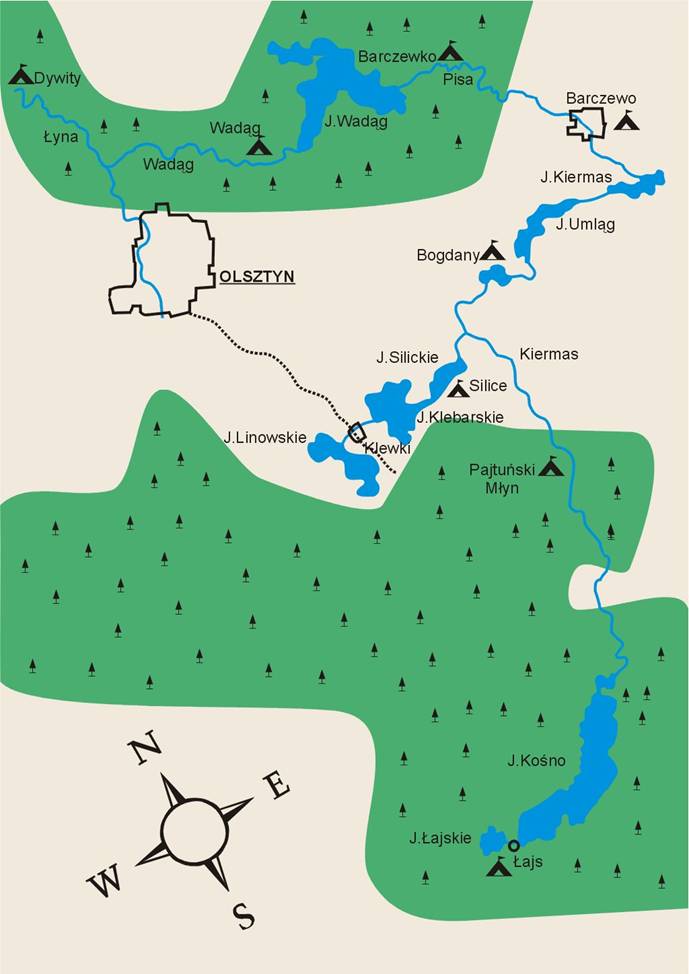 Day 1, Łajs – Pajtuński Młyn 15.15 km
Starting point: Łajs. A border village for the historical regions of Warmia and Mazury, located between Lake Łajskie and Lake Kośno. Lake Kośno, the largest lake in the Purda gmina, is a wildlife reserve protecting the natural landscape of the lake surrounded by forest. The lake has the total area of 562.5 ha, average depth of 13.7 m, maximum depth of 44.6 m. Kayaks are launched on a beach belonging to the Adler guest house, which also provides a tent site. Keep to the left shore, heading north-east. At the lake necking in its northern end, approach the right shore in order to get into the Kośna river.
7.09 km Kośna river outlet from Lake Kośno. The river twists and winds through forest areas. We are passing a road bridge and several smaller bridges over which forest trails wend their way.
9.36 km Purdka. To the left, behind the railway viaduct, there is a large meadow surrounded by a forest, where you can rest after first paddling efforts. The river slowly flows out of the forests and leads its way through meadows and pastures, taking sharp turns.
12.71 km Road bridge, with the village of Pruda located 0.5 km to the east from it. Possible docking 0.5 km before the bridge, where shops and the gmina office are. In the village, there is a 14th-century Gothic church, rebuilt in the later years. Inside the church is an interesting altar of Saint Hubertus, the patron saint of hunters, with a rich collection of trophies. In the first half of the 20th century, Purda was inhabited by a considerable Polish population, with the Union of Poles in Germany as well as a Polish school and kindergarten in the village.
15.15 km Różany Dwór in Pajtuński Młyn. A guest house and campsite on the left bank of the Kośna river, food. A charming site in the middle of the forest. The guest house includes a small stable and a historical, late-18th-century mill, which currently serves as a hydroelectric power station. Near the mill, there is a statue of John of Nepomuk, a very popular saint in Warmia, the patron of rivers and people living off water.
Day 2, Pajtuński Młyn – Silice 7.02 km
15.32 km A portage over the mill dam on the right bank of the river. The river continues to flow through forests.
16.79 km Patryki, ruins of a 20th-century watermill, another portage by the right bank of the river.
18.62 km Patryki-Rybaczówka. The Kośna river flows into a vast marsh of fishing ponds, which is also the river’s mouth. The remaining part of the trail wends its way through the Elżbieta Canal and Kiermas Canal, where the Kośna river has been directed. Once more, we portage the kayaks for 200 m to the Kiermas Canal, leading us through reed fields, exposing water, the sky and...reed beds.
2l.85 km the Wiktoria Canal flowing into the Kiermas river from the left and leading to Lake Silickie.
23.12 km Silice-aqueduct. A rare example of hydrotechnical engineering, a water intersection of two canals, with the Elżbieta Canal flowing over the Wiktoria Canal. Once on Lake Silickie, a small water body with the area of 50 ha, head to the right shore.
23.62 km Tadeusz Iliński’s agritourism farm where we can stay for the night, dine and enjoy attractions of the farm.
Day 3, Silice – Barczewo 14.15 km
25.39 km On our way back to the Kiermas Canal via the Wiktoria Canal, we turn left.
27.36 km Lake Bogdańskie with the area of 23.5 ha, the village of Bogdany situated on its left shore, with tent sites, guest houses and food points.
27.86 km A bridge, behind which the Kiermas river flows out of the lake.
29.5 km Lake Umląg. This shallow lake has an average depth of 1.9 m and maximum depth reaching 5 m.
32.53 km Krupoliny. A road bridge, behind which we paddle out of the lake and make another short section of the river, running widely between the reed fields.
32.84 km Lake Kiermas with the area of 70 ha, an average depth of 3.1 m and maximum depth of 9.3 m. Keep near the left shore.
34.77 km The mouth of the Kiermas river in the 2/3 of the lake’s length, on the left shore, leading to Barczewo.
37.77 km Barczewo, a town in Warmia by the Pisa river, with town privileges awarded in 1364. Currently 7.5 thousand inhabitants. The town has several interesting sites, including Saint Anne’s 14th-century Gothic parish church, Saint Andrew’s Gothic monastery church (with a Renaissance tombstone of Cardinal Andrew Báthory, a Prince-Bishop of Warmia, and a nephew of King Stephen Báthory of Poland), a 19th-century town hall in the market square. Born in Barczewo was F. Nowowiejski, a composer whose compositions include the poem entitled “Rota” (the Oath), oratorios, the opera “Legenda Bałtyku” (the Legend of the Baltic), songs and military marches. There is a biographical museum in the Nowowiejskis’ House. A former synagogue houses a kayak dock, while a campsite is situated at the fire station. Coming to the town, we head towards the road bridge and dock at the left bank.